Software
Flumen
Flush
Fluviz
Simp
Support
Manuals
Publications
SIMP (surface SIMPlification) reduces high resolution terrain data with greedy insertion. It is based on a refinement algorithm that insert the point of highest error on each pass (Heckbert and Garland 1997). The orgininal amount of data can usually be reduced to less than 5% without loosing accuracy. SIMP makes use of R. J. Renka's TRIPACK library. Low non-ground points are removed by morphological filtering (see Beffa&Lumpert 2010).
Usage:
simp in_file -t tol -o out_file -z zmin -Z zmax -h hull_file
where in_file = file with data of surface points in xyz-format (= ASCII table with x, y and z values in the first, second and third column, respectively), tol = mean error of the z-values of the remaining nodes [m], out_file = name of result file, zmin zmax = minimum and maximum z-values of the nodes to be processed, hull_file = file containing a polygon enclosing the nodes to be processed. A polygon file consists of two space delimited columns with the x- and y-coordinates of the polygon vertices in the first and second column. Additional options are described in the help text that is writen to the screen after typing simp without options.
Example:
simp nodes.xyz -t 0.2 -Z 745.0 -o nodes.out
will process the nodes on file nodes.xyz with z-values smaller than 745.0 m and writes inserted nodes to nodes.out until the mean error of the remaining nodes is smaller than 0.2 m.
- since version 3.0:
- unlimited node number (depending on system RAM)
- treatment of large data files in tiles
(computational units)
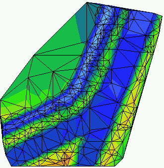 |
Figure: TIN of a simplified surface of a river confluence. The original 2x2m grid has been reduced to 15% using SIMP given a tolerance of 0.1 m. |
Platforms
 Under Windows in a
DOS-Command-Window.
Under Windows in a
DOS-Command-Window. (c) 2021 fluvial.ch